
Ror Khatiyan
A khatiyan is Odisha's Record of Rights for one land holding. Every column read on a real one from Bhulekh, names masked, and how to search it free.
A khatiyan is the Record of Rights (RoR) for one land holding in Odisha, the adhikar abhilekh. It names the tenants who hold the land, with each one's father's or husband's name, caste and residence, their class of right and the rent due, then lists every plot with its land class (kisam), boundaries and area. Every entry is presumed correct until it is proved wrong (section 13(3) of the Orissa Survey and Settlement Act, 1958). Anyone can read it free on Bhulekh Odisha, without a login.
A real khatiyan, as Bhulekh shows it
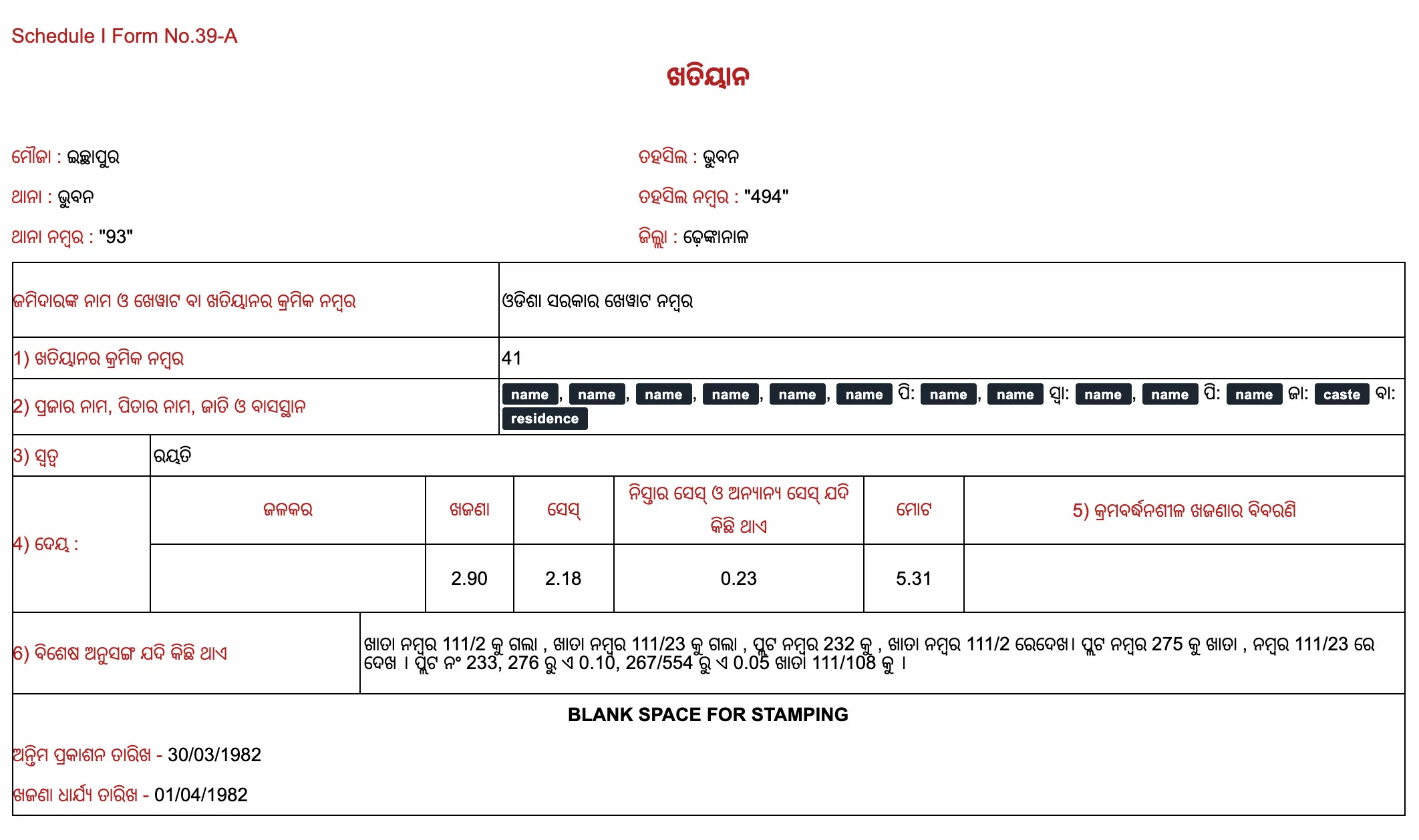
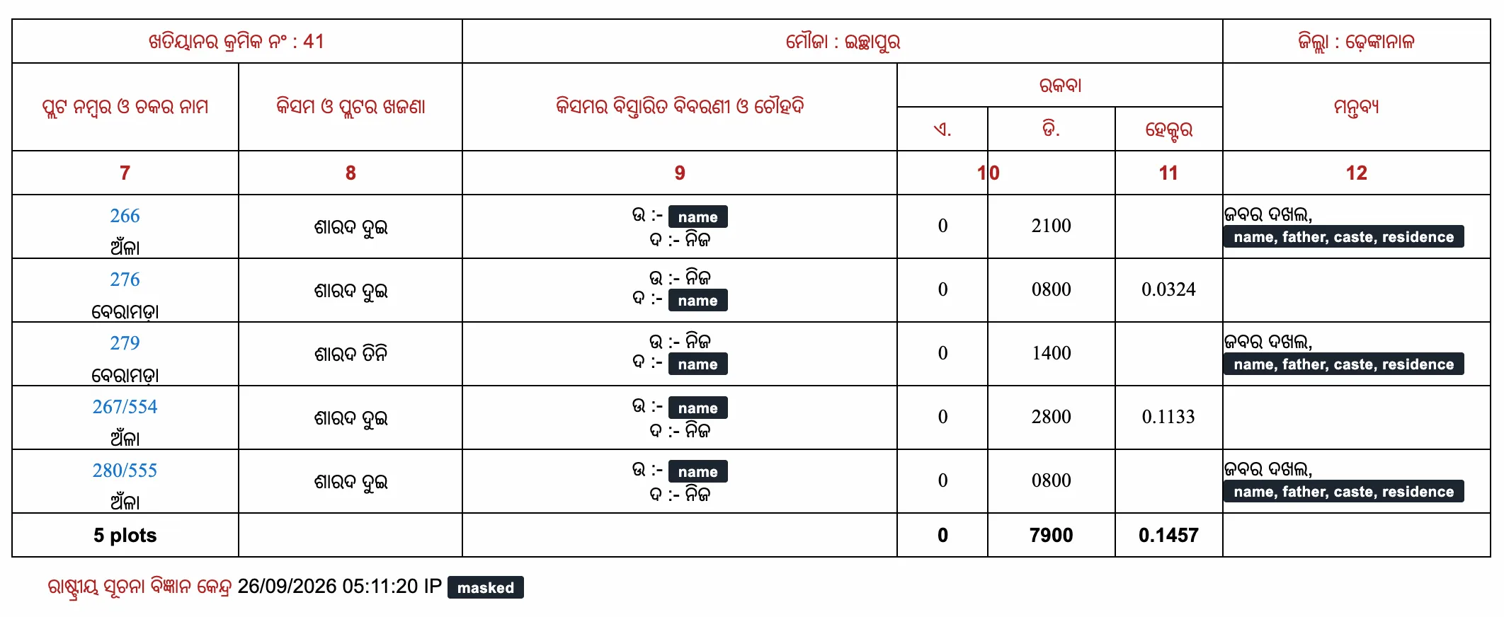
This is khatiyan 41 of mouza Ichhapur, in Bhuban tahasil of Dhenkanal district, as Bhulekh Odisha showed it on 26 September 2026. It is a public record: anyone can open it on the portal. We masked the names, castes and residences, and the IP address the portal prints at the foot. Nothing else is changed.
The form is Schedule I, Form No. 39-A. The front says who holds the land, on what right and for what rent (columns 1 to 6); the plot table says which land it is, of what class and how much (columns 7 to 12).
The front: who holds the land, on what right, for what rent
- The header names the village (mouza, ମୌଜା) Ichhapur, the tahasil Bhuban, the police station (thana, ଥାନା) Bhuban and the district Dhenkanal, with two reference numbers: tahasil number 494 and thana number 93.
- The landlord line (ଜମିଦାରଙ୍କ ନାମ) reads ଓଡିଶା ସରକାର, the Government of Odisha. The Act splits a Record of Rights in two: the khewat, which shows proprietary interests, and the khatiyan (section 11(5) of the Orissa Survey and Settlement Act, 1958). Every person, or group holding jointly, gets a khatiyan of its own (Rule 22 of the Orissa Survey and Settlement Rules, 1962).
- Column 1, the khatiyan number: 41. Numbers run village by village, so a khatiyan number means nothing without its village; that is why Bhulekh asks for the district, the tahasil and the village first.
- Column 2, the tenants (ପ୍ରଜା): the name of each tenant (Rule 21(i)), then a relative, marked by the relationship to the tenant: ପି: (pita, father) or ସ୍ଵା: (swami, husband); then the caste (ଜା:, jati) and the residence (ବା:, basasthana). Eight people hold this one jointly: six share one father, one is recorded with her husband and one with another father, and one caste and one residence close the entry. A sale by some of them passes only their shares (section 44 of the Transfer of Property Act, 1882), so a buyer of the whole needs every one of them to sign.
- Column 3, the right (ସ୍ଵତ୍ଵ), the class the tenants belong to (Rule 21(ii)): ରୟତି, rayati. They hold as raiyats under the landlord named above.
- Column 4, the dues (ଦେୟ), the rent and the charge for water (Rule 21(vi)): water rate (ଜଳକର) blank, rent (ଖଜଣା) ₹2.90, cess (ସେସ୍) ₹2.18, nistar and other cess (ନିସ୍ତାର ସେସ୍) ₹0.23, total ₹5.31.
- Column 5, a rent that rises in steps (Rule 21(vii)): blank here.
- Column 6, special incidents (ବିଶେଷ ଅନୁସଙ୍ଗ), the special conditions of the tenancy (Rule 21(ix)). Here it records land that left the holding, and where to read it now (ଦେଖ, see): plot 232 went to khata 111/2, plot 275 to khata 111/23, and plot 233, 0.10 acre of plot 276 and 0.05 acre of plot 267/554 to khata 111/108.
- At the foot, the date of final publication (ଅନ୍ତିମ ପ୍ରକାଶନ ତାରିଖ), 30 March 1982, and the date the rent was fixed (ଖଜଣା ଧାର୍ଯ୍ୟ ତାରିଖ), 1 April 1982. A record is finally published after its draft, the objections and the appeals (sections 12 to 12-B); from then it is conclusive evidence that it was duly made, and every entry is presumed correct until proved wrong (section 13(3)).
The plot table: which land, of what class, how much
- Column 7, the plot number and the chaka (ଚକ), the named block of fields: plots 266, 267/554 and 280/555 lie in Anla (ଅଁଳା), plots 276 and 279 in Beramada (ବେରାମଡ଼ା). The record must agree with the village map, which carries the same plot numbers (section 11(6)).
- A number with a slash is a newer plot cut from an older one. Bhulekh lists 537 plain plot numbers for Ichhapur, up to 538, and 149 more written with a slash, each ending in a number from 539 to 679: 267/554 is plot 554, cut from plot 267, which is still on the list. A piece of a piece carries all three, as in 24/638/669.
- Column 8, the land class (kisam, କିସମ). The settlement grouped a village's farm land into classes by the crop, the soil, where the land lies and how it is watered, put every plot in one (Rule 48(2)), and set its rent by the class. All five plots here are ଶାରଦ (sarad) land: four in class ଦୁଇ (two), plot 279 in class ତିନି (three). The column has room for each plot's rent too, blank here. Using farm land for anything else needs the authorised officer's conversion order and a fee, after which the kisam is corrected (section 8-A of the Orissa Land Reforms Act, 1960).
- Column 9, the land class in detail and the boundaries (ଚୌହଦି): here the north (ଉ) and south (ଦ) neighbours. ନିଜ, own, means the same holding continues on that side.
- Columns 10 and 11, the area (ରକବା): acres (ଏ.) and decimals (ଡି.), then hectares (ହେକ୍ଟର). Decimals are printed with four digits, so 0 and 2100 is 0.21 acre, or 21 decimals, a decimal being a hundredth of an acre. The holding is 0.79 acre in five plots.
- The hectare total, 0.1457, adds only the two plots that carry a hectare figure (276 and 267/554). 0.79 acre is 0.3197 hectare at 0.4047 hectare to the acre (section 2(30) of the Orissa Land Reforms Act, 1960): read the acre column.
- Column 12, remarks (ମନ୍ତବ୍ୟ). On plots 266, 279 and 280/555 it reads ଜବର ଦଖଲ, forcible possession, then the name, father, caste and residence of someone who is not a tenant in column 2. The record names others in possession of 0.43 of the holding's 0.79 acre.
How to search a khatiyan on Bhulekh
- Open Bhulekh Odisha (bhulekh.ori.nic.in). Reading a record needs no login.
- Choose the district, then the tahasil, then the village. The portal fills in the RI circle.
- Search by Khatiyan, which is selected by default, or by Plot or Tenant; pick the number or the name, and press View RoR.
- The front and the plot table open on one page. Print keeps a copy, and Pay Land Revenue opens the ePauti portal to pay the land revenue (Bhulekh's user manual).
What a khatiyan does not tell you
It shows whom the revenue record names, and each entry stands only until it is proved wrong. It does not show a mortgage, a pending suit or an unregistered agreement: those sit in the Encumbrance Certificate, which the Sub-Registrar office issues, and in the court records.
The record is kept up to date by mutation (section 16; Rule 34 of the 1962 Rules). A sale that has not been mutated yet does not appear, so the name on a khatiyan can be out of date.
This is the current settlement's record, the hal khatiyan; the settlement before it left an older one, the sabik khatiyan. Where a later record changed an entry, the later entry is presumed correct, and the earlier one still counts as evidence of how things stood when it was made (section 13(3)).
Reading it before a purchase
- Match the seller's name, father's name, khatiyan number and plot number against the sale deed and the Encumbrance Certificate.
- Count the tenants in column 2: every joint holder has to sign, or you buy only the shares of those who do.
- Check the area: no one can sell more land than the area recorded in their name, and the acre column is the one to read.
- Check the kisam: farm land needs a conversion order before it is used for anything else.
- Read columns 6 and 12: land sent to another khata, and anyone recorded in possession by force. Walk the plots before paying.
Read next
Checking it before money moves
You can read the land record from a name or a plot number, and search the same name across the District Courts, the High Court, the tribunals and the Supreme Court. Both answer in minutes and cite the page each fact came from, so an advocate can check the source rather than take a summary on trust.
100 credits free · no credit card required
Related questions
- Khatiyan Check — read the Record of Rights, and what it does not show
- Online Khatiyan — read the Record of Rights, and what it does not show
- Bhunaksha Odisha: See Your Plot's Map Online, Free
- Bhulekh — read the Record of Rights, and what it does not show
- Bhulekh Odisha Plot Details — read the Record of Rights, and what it does not show
- Bhulekh Odisha Plot Details By Name — search Odisha land records by owner name